


 Manicouagan Property


 DESCRIPTION OF THE MANICOUAGAN PROPERTY
Ex-In property consists of 75 claims (fig.2) in the NTS 22K16
DESCRIPTION OF THE MANICOUAGAN PROPERTY
Ex-In property consists of 75 claims (fig.2) in the NTS 22K16 subdivisioncovering electromagnetic (EM) conductors situated
some 50 km North-East of the Manic 5 electric power dam (fig.
1). Because of the rugged terrain the property is easily
accessible only by helicopters even if the North limit of the
claims is only 10 km south of the road leading from Manic 5 to
Goose Bay. A ten day Beep Mat project by Ex–In made in
August 2011 confirms both the presence of nickel mineralisation
and the feasibility of sampling with Beep Mats a 40 km long
sequence of nickel bearing conductors surrounding a basic
intrusive.
MINERALIZED SHOWINGS
1)
A compilation map by Soquem (Figure 3) shows four sites
sampled in 1996-97 and one in 1998:
Site 1: On the site situated at the south east, around line 32S,
11 mineralised surface blocks were collected probably in 1998
the best one grading 2.8% Cu, all the other assays being about
0.5% or less.
Site 2: 1.5 km north of site 1, on line 16S, 2 samples on
adjacent lines were sampled, 0.3% Ni.
Site 3: 3 km north of site 2, on line 1S, a trench was channel
sampled on a Beep Mat conductor and the DDH under the
trench intersected 1.3: nickel over 2.1 meters. But no other
trenches seem to have been attempted in the vicinity and no
assays are reported from the 5 DDH drilled to extend the first
intersection.
Site 4: 8 km north-west of site 3, on line 85, a sample gave
0.4% nickel.
Site 5: Situated 5 km west of site 4, on line 85W, assayed 1.4%
Ni.
Perhaps tired of drilling garnets the last DDH of the program of
checking gravity anomalies the geologist instead confirmed this
showing by intersecting 1,3% Ni and 0,4% Cu. over 0.61 cm.
2)
The 2011 exploration program run by Ex-In:
Ex-In ran this 11 days field program to familiarise with the area
and to test the local conditions in which to run a large Beep Mat
prospecting program. Once dropped by helicopters the three
men crew plus the cook cum writer worked from a fixed camp
localized close to the showing of Jean Fortin. Two specific aims
were achieved:
a) The lateral extension of the mineralized Bob Fortin Ni
showing, was sampled by five trenches at a 75 meters interval.
The mineralisation was continuous, as expected. The best
assays obtained from grab or chip samples after a trench was
blasted perpendicular to the conductor revealed: 1.1 % Ni with
0.4% Cu. Traces of cobalt were also present. A lot of samples
graded around 0.5% Ni.
b) The crew was able to discover, trench and blast an average
of slightly better than a sample a day. The overburden was
shallow, usually less than a meter deep. Some of the horizons
were graphitic, but two of the new sites sampled were
nickeliferous. One of the two, situated near the top of the hill
some 500 meters North of the known Bob Fortin Ni showing,
revealed 0.7% Ni and 0.2% Cu from a grab sample. There the
bedrock sampled was very altered by weathering.
c) Nearly a third of the he hill side was covered by windfalls, the
big trees lying one over another. To move with a 30 kg drill on
your back one has to cut a trail with a chain saw. One of the
three crew members spent half of his time doing just that,
assisted by the cook. If one plans to work from a camp one will
have to cut a trail parallel to the direction of the conductors that
we intend to sample.
A compilation map (fig.3) for 22K16 region shows the potential
of the area: Only a few rock samples in the areas have been
collected by previous companies working in the area. Most of
the territory is virgin and remains to be explored, sampled and
tested.
The second compilation map (fig. 5) shows the different
showings found by Explorateurs-Innovateurs de Québec inc. but
also from previous exploration programs held by SOQUEM.
Geological direction and dip of the bedrock, claims in good
standing, topography and lakes, DDH, samples assays, EM
conductors and other pertinent data superposed on the same
map.
GEOPHYSICS
The area surrounding the basic intrusive has been covered by
airborne surveys perhaps not of today’s quality but the
numerous targets that they defined have been confirmed by the
MaxMin survey, and the resulting conductors warrant follow up.
The gravity survey done in an area of such a rugged topography
and on flagged lines is of little help to search nickel targets,
especially that the eight most evident anomalies were already
drilled, and nothing of value was discovered.
The Beep Mat appears a valid alternative approach to test all
these conductors in this area covered generally by shallow
overburden. Early models discovered in 1996 and 1998
discovered the only two significant Nickel showings, both
confirmed by DDH as shown on map. As EM conductors are
caused also often by layers of graphite or pyrrhotite, one must
accept to sample also many barren ones caused by graphite or
pyrrhotite. and cobalt associated with Pyrrhotite, Graphite,
Gold, Silver, Copper (Chalcopyrite), and many other minerals
may be found with the Beep Mat. A few showings were
described by SOQUEM and were coming to the surface with
nickel mineralization. These showings were indicated on the
second map in appendix. The fact that pyrrhotite is present in
the field and described in the discovery logs suggests that it
could be possible to find more showings prospecting with Beep
Mats from the surface. This method has been tested during
2011 prospecting program and has proven to be very successful.
A few graphitic horizons were also found and tested. Using this
method is cost effective and allows to better delineate the
horizons and to get to know which ones reveal sulphurs and
which one is barren. As it was the case in 2011, it seems
different horizons contain Nickel potential.
ABSTRACT
This nickel promising property was not properly explored by
Soquem. The numerous conductors carefully localized should be
sampled at a reasonable interval. To confirm our impression Ex-
In ran a 10 day Beep Mat prospecting campaign in 2011 which
confirmed that
1) MaxMin conductors often respond to the Beep Mat;
2) They are easy to sample with a shovel and plugger
with dynamite;
3) The nickel enriched conductors could be followed
laterally for 300m;
4) Among the five virgin conductors sampled by Ex-In,
two were mineralized in nickel.
subdivisioncovering electromagnetic (EM) conductors situated
some 50 km North-East of the Manic 5 electric power dam (fig.
1). Because of the rugged terrain the property is easily
accessible only by helicopters even if the North limit of the
claims is only 10 km south of the road leading from Manic 5 to
Goose Bay. A ten day Beep Mat project by Ex–In made in
August 2011 confirms both the presence of nickel mineralisation
and the feasibility of sampling with Beep Mats a 40 km long
sequence of nickel bearing conductors surrounding a basic
intrusive.
MINERALIZED SHOWINGS
1)
A compilation map by Soquem (Figure 3) shows four sites
sampled in 1996-97 and one in 1998:
Site 1: On the site situated at the south east, around line 32S,
11 mineralised surface blocks were collected probably in 1998
the best one grading 2.8% Cu, all the other assays being about
0.5% or less.
Site 2: 1.5 km north of site 1, on line 16S, 2 samples on
adjacent lines were sampled, 0.3% Ni.
Site 3: 3 km north of site 2, on line 1S, a trench was channel
sampled on a Beep Mat conductor and the DDH under the
trench intersected 1.3: nickel over 2.1 meters. But no other
trenches seem to have been attempted in the vicinity and no
assays are reported from the 5 DDH drilled to extend the first
intersection.
Site 4: 8 km north-west of site 3, on line 85, a sample gave
0.4% nickel.
Site 5: Situated 5 km west of site 4, on line 85W, assayed 1.4%
Ni.
Perhaps tired of drilling garnets the last DDH of the program of
checking gravity anomalies the geologist instead confirmed this
showing by intersecting 1,3% Ni and 0,4% Cu. over 0.61 cm.
2)
The 2011 exploration program run by Ex-In:
Ex-In ran this 11 days field program to familiarise with the area
and to test the local conditions in which to run a large Beep Mat
prospecting program. Once dropped by helicopters the three
men crew plus the cook cum writer worked from a fixed camp
localized close to the showing of Jean Fortin. Two specific aims
were achieved:
a) The lateral extension of the mineralized Bob Fortin Ni
showing, was sampled by five trenches at a 75 meters interval.
The mineralisation was continuous, as expected. The best
assays obtained from grab or chip samples after a trench was
blasted perpendicular to the conductor revealed: 1.1 % Ni with
0.4% Cu. Traces of cobalt were also present. A lot of samples
graded around 0.5% Ni.
b) The crew was able to discover, trench and blast an average
of slightly better than a sample a day. The overburden was
shallow, usually less than a meter deep. Some of the horizons
were graphitic, but two of the new sites sampled were
nickeliferous. One of the two, situated near the top of the hill
some 500 meters North of the known Bob Fortin Ni showing,
revealed 0.7% Ni and 0.2% Cu from a grab sample. There the
bedrock sampled was very altered by weathering.
c) Nearly a third of the he hill side was covered by windfalls, the
big trees lying one over another. To move with a 30 kg drill on
your back one has to cut a trail with a chain saw. One of the
three crew members spent half of his time doing just that,
assisted by the cook. If one plans to work from a camp one will
have to cut a trail parallel to the direction of the conductors that
we intend to sample.
A compilation map (fig.3) for 22K16 region shows the potential
of the area: Only a few rock samples in the areas have been
collected by previous companies working in the area. Most of
the territory is virgin and remains to be explored, sampled and
tested.
The second compilation map (fig. 5) shows the different
showings found by Explorateurs-Innovateurs de Québec inc. but
also from previous exploration programs held by SOQUEM.
Geological direction and dip of the bedrock, claims in good
standing, topography and lakes, DDH, samples assays, EM
conductors and other pertinent data superposed on the same
map.
GEOPHYSICS
The area surrounding the basic intrusive has been covered by
airborne surveys perhaps not of today’s quality but the
numerous targets that they defined have been confirmed by the
MaxMin survey, and the resulting conductors warrant follow up.
The gravity survey done in an area of such a rugged topography
and on flagged lines is of little help to search nickel targets,
especially that the eight most evident anomalies were already
drilled, and nothing of value was discovered.
The Beep Mat appears a valid alternative approach to test all
these conductors in this area covered generally by shallow
overburden. Early models discovered in 1996 and 1998
discovered the only two significant Nickel showings, both
confirmed by DDH as shown on map. As EM conductors are
caused also often by layers of graphite or pyrrhotite, one must
accept to sample also many barren ones caused by graphite or
pyrrhotite. and cobalt associated with Pyrrhotite, Graphite,
Gold, Silver, Copper (Chalcopyrite), and many other minerals
may be found with the Beep Mat. A few showings were
described by SOQUEM and were coming to the surface with
nickel mineralization. These showings were indicated on the
second map in appendix. The fact that pyrrhotite is present in
the field and described in the discovery logs suggests that it
could be possible to find more showings prospecting with Beep
Mats from the surface. This method has been tested during
2011 prospecting program and has proven to be very successful.
A few graphitic horizons were also found and tested. Using this
method is cost effective and allows to better delineate the
horizons and to get to know which ones reveal sulphurs and
which one is barren. As it was the case in 2011, it seems
different horizons contain Nickel potential.
ABSTRACT
This nickel promising property was not properly explored by
Soquem. The numerous conductors carefully localized should be
sampled at a reasonable interval. To confirm our impression Ex-
In ran a 10 day Beep Mat prospecting campaign in 2011 which
confirmed that
1) MaxMin conductors often respond to the Beep Mat;
2) They are easy to sample with a shovel and plugger
with dynamite;
3) The nickel enriched conductors could be followed
laterally for 300m;
4) Among the five virgin conductors sampled by Ex-In,
two were mineralized in nickel.
 © Copyright 2014 - All rights reserved
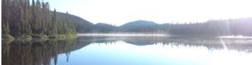
Figure 1: Location Map
of the Manicouagan Project
Click thumbnail to enlarge
© Copyright 2015 - All rights reserved
© Copyright 2014 - All rights reserved
Figure 1: Location Map
of the Manicouagan Project
Click thumbnail to enlarge
© Copyright 2015 - All rights reserved
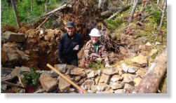
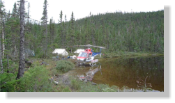
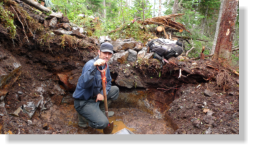
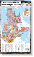 Figure 4: Frédéric Gaucher and Edwin
Gaucher in a trench done with explosives.
A grab sample returned 1.3% Ni and 0.4% Cu.
Figure 7: Access by helicoptere to the
base camp, situated 10km from the closest
road.
Figure 6: The Nickel horizon was confirmed
to be continous on at least 300m. Trenches
each 100m were dug and blasted to verify
the continuity of the mineralization. The
extensions are open and the EM horizon is
continous on a 40 km long sequence of
nickel bearing conductors surrounding a
basic intrusive
Figure 4: Frédéric Gaucher and Edwin
Gaucher in a trench done with explosives.
A grab sample returned 1.3% Ni and 0.4% Cu.
Figure 7: Access by helicoptere to the
base camp, situated 10km from the closest
road.
Figure 6: The Nickel horizon was confirmed
to be continous on at least 300m. Trenches
each 100m were dug and blasted to verify
the continuity of the mineralization. The
extensions are open and the EM horizon is
continous on a 40 km long sequence of
nickel bearing conductors surrounding a
basic intrusive
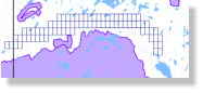 Figure 2: Claims held by
Explorateurs-Innovateurs de
Québec in the NTS 22K16 area
Figure 2: Claims held by
Explorateurs-Innovateurs de
Québec in the NTS 22K16 area
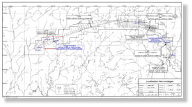 Figure 3: SOQUEM 1978 Compilation Map of the
entire property showing MaxMin conductors,
position of all DDH and grab samples with assays.
Figure 3: SOQUEM 1978 Compilation Map of the
entire property showing MaxMin conductors,
position of all DDH and grab samples with assays.
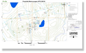 Figure 5: Ex-In compilation map of work
conducted in 2011.
Figure 5: Ex-In compilation map of work
conducted in 2011.
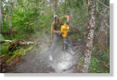 Figure 8: Drilling the outcrop to introduce
sticks of dynamite and sample the bedrock.
Figure 8: Drilling the outcrop to introduce
sticks of dynamite and sample the bedrock.

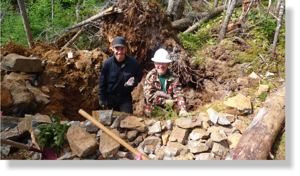
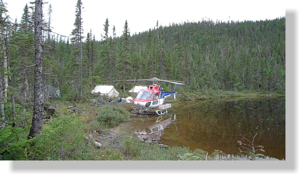

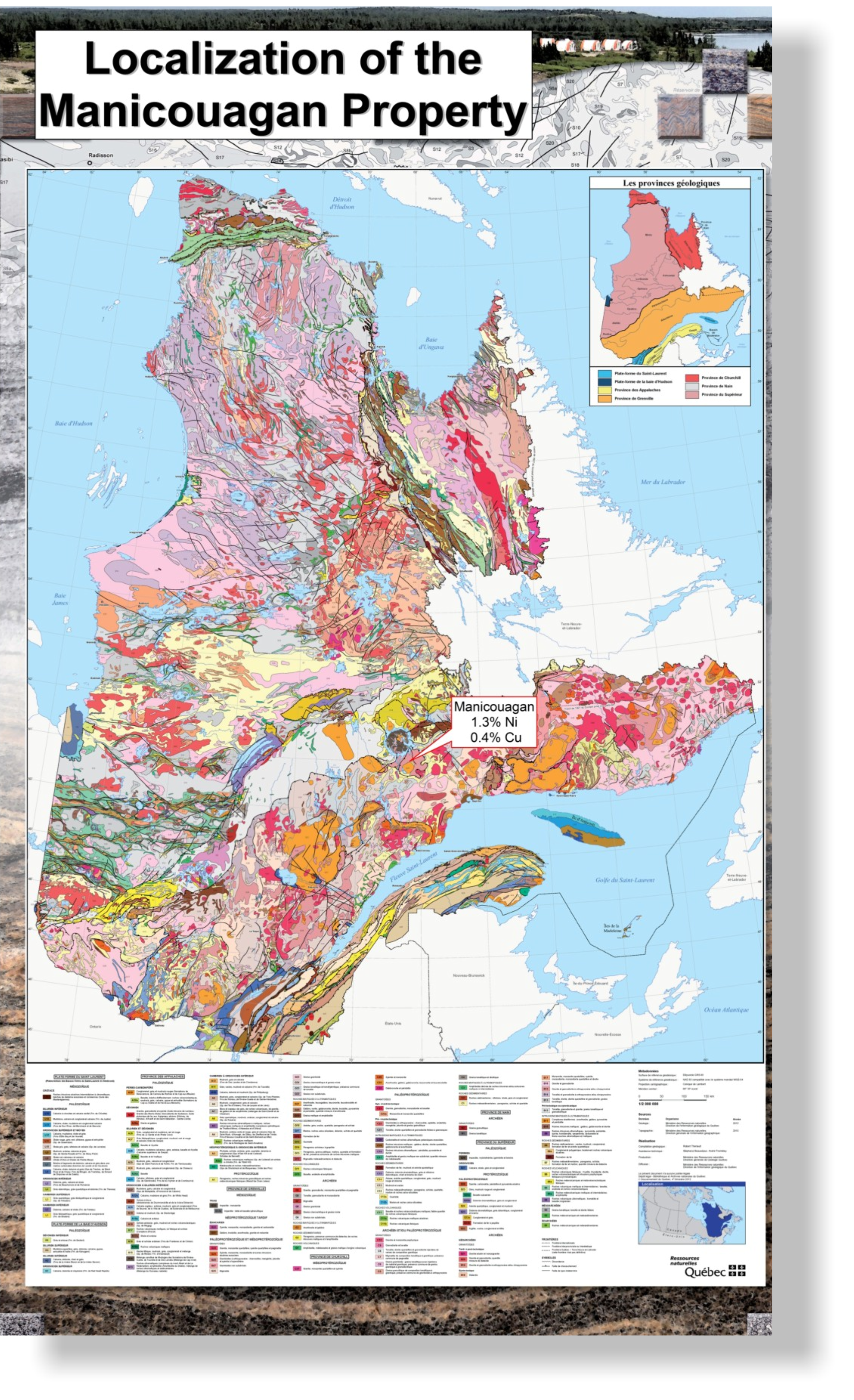 Figure 4: Frédéric Gaucher and Edwin
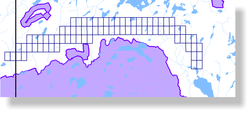 Figure 2: Claims held by
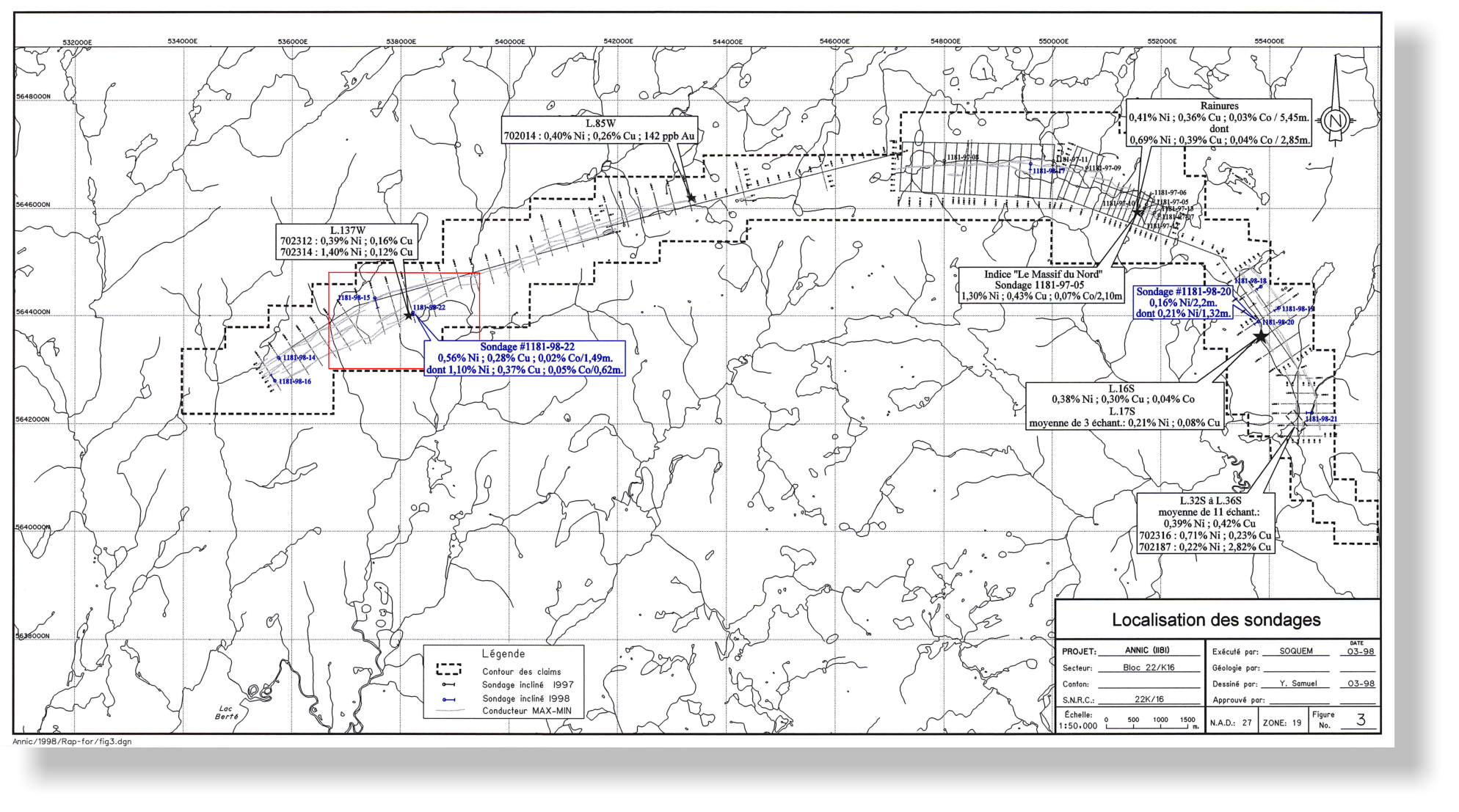 Figure 3: SOQUEM 1978 Compilation Map of the
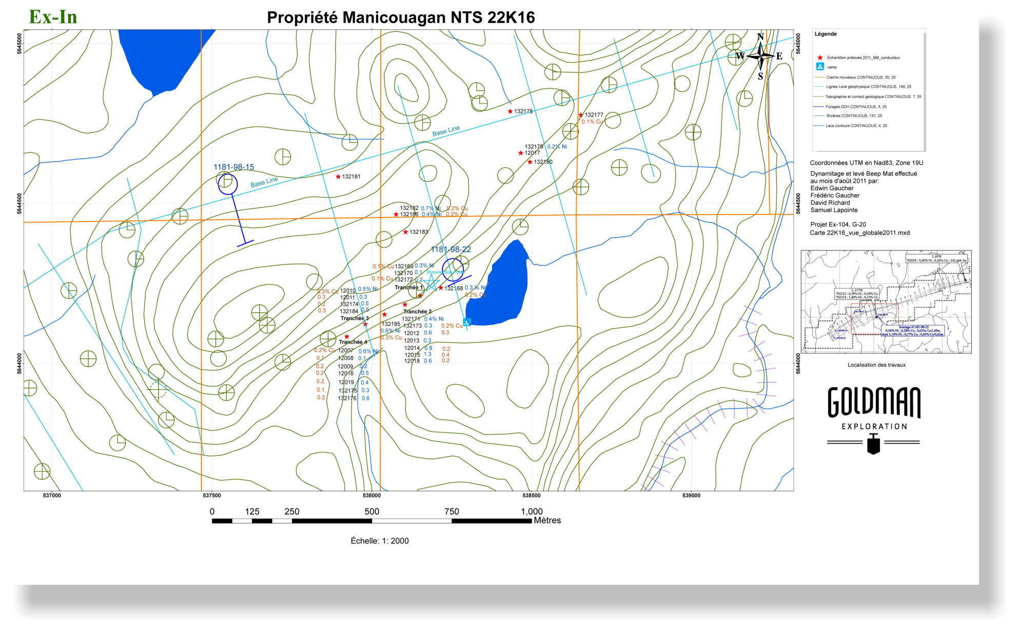 Figure 5: Ex-In compilation map of work
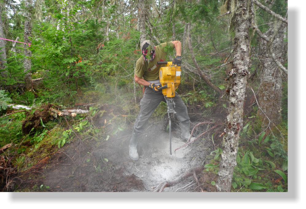 Figure 8: Drilling the outcrop to introduce


